From Toxic Waste Site to Dog Park: A Peculiar Transformation in Suburban New Jersey
by Ismail Hozien
Site Description:
I hope to find through my research, the factors that caused the radioactive dump in my hometown, Wayne, New Jersey, to become a dog park. I hope to find court cases relating to W.R. Grace & company to clean up the site. I am possibly looking three or more legal processes here: 1) How the site was shut down and demolished. 2) How it ended up getting professionally cleaned. 3) How it suddenly became a dog park, after being vacant for years. What particularly interests me in a case like this is that there are so many factors at play… it seems like something really big is going on unnoticed. For example, Wayne, New Jersey is a majority white suburban town, a big one in fact. There have been a number of businesses that have recently opened up in very close proximity to the site. In addition to all of those factors, there is a pretty large local farm downhill from the site… one could just imagine all the harmful stuff that gets carried from the site down to the farm whenever it rains. All of these factors at play pose a lot of questions.
Why has a plot of land that has been empty for years suddenly been transformed into this park? Who were the major decision makers? How has W.R. Grace and Company been involved? How has Wayne Interim Storage been involved? How has the EPA and other branches of the government been involved? Were the locals a part of any of these processes and how? Why was the land originally chosen as dump for thorium, uranium and other metals? What do the local demographics look like? Have real estate prices been affected (maybe this is why new businesses have started to pop up)?
Final Report:
Wayne, New Jersey, my hometown, is a pretty large suburban town, home to mostly middle-class residents. It has multiple lakes, businesses, public and private schools involved in sports, and even historical sites. It seems to be a nice place to call home, or so I thought. Although on the outside my hometown seems like clean environment for children to grown up in and for elders to retire, in reality it has a dark past that hasn’t yet been forgotten by all. Decades ago, in the late 40s, a company called Rare Earths Inc. moved into the town near a local farm and started operating. The company would extract Thorium, a radioactive element. In the 50’s another company, W.R. Grace would take over and continue the operations Rare Earths Inc. started. The real issue was however, that W.R. Grace didn’t abide by ethical standards while operating. For instance, in order to get rid of the liquid waste from the processing, the company would dilute the waste and then proceed to pour it down a storm sewer that would carry the waste to a nearby brook in which children would play.
W.R. Grace’s harmful operations and failure to control these operations led to a contamination of the Pompton Plains Crossroads area of Wayne, New Jersey. This contamination didn’t sit well with the local civilians who rose and took action. It took the U.S. government’s direct involvement over an extended period of time to clean up the site and surrounding areas. Even then the Pompton Plains area still contains contaminants. It was only after decades of federal efforts to restore the site, that the site was re-advertised as a pleasant commercial and recreational area for the public.
In this paper I will mention the harmful operations W.R. & Grace practiced at its Wayne Interim Storage Site (WISS) and how the locals and government strove to decrease the harms and clean up the area. I will also analyze why W.R. & Grace chose the town of Wayne as the site for their Thorium ore processing. After this I will discuss how, once the site was cleaned up by the U.S. government, the site and its surrounding areas were re-advertised to the public.
I have relied on a variety of sources in preparing this research. These include official surveys, from different years and from different organizations, both governmental and private, in addition to a U.S. government FUSRAP factsheet. I also used a New York Times article from the 80s, before the site was cleaned up, that mentioned the reactions of the locals upon discovering the dark history of the site. I also used a master’s thesis done on the WISS from New Jersey Institute of Technology.
The paper will start out by discussing the history of the site from when W.R. & Grace moved in. It will mention the significant events that took place along the way. In order to compliment the official history from the various reports and factsheets, I will use the oral interview I conducted to get a local perspective on this history. After mentioning this I will discuss the grassroots action and the multi-step governmental response to clean up the high amounts of radiation on and near the. Finally, I will discuss how the site has been re-advertised to the public and how it has become more economically vibrant. It is here that I will use my image analysis as well as real-estate information. Finally I will analyze an EJScreen map and do a data analysis of the statistics related to the area the site is located in.
In the year 1948, Rare Earths Inc. decided to move into Wayne, NJ to start extract the radioactive element of Thorium and other metals from monazite sands. In order to understand why Rare Earths Inc. chose the town of Wayne, New Jersey, out of all places to run its harmful operations we must understand the context of the time. Rare Earths Inc. first moved into Wayne N.J. in the year 1948, about three years after World War II and a year into the Cold War.[1] The mindset of the United States of America was to mobilize the nation to face what the government perceived as a threat abroad and even at home, in this case the threat was communism. Today the town of Wayne is a large suburban town with a majority white population. However, this wasn’t the case in the 40s and 50s. As a New York Times article from the early 80’s mentions, “For residents of the area, many of whom moved into housing tracts built in old cow pastures in the early 60’s, the findings have produced more questions than answers about long-term health consequences.”[2] As we can see this article highlights the fact that it was only in the 60’s, over a decade after the Wayne Interim Storage Site started operating, that the old cow pastures, originally owned and run by the Sheffield family, were converted into houses for new residents. It seems that Rare Earths Inc. encountered no serious problems moving into the Pompton Plain Crossroads area of Wayne due to the fact that the area seemed to be sparsely inhabited. The two families who owned most of the land in the area were the Sheffield family and the Kuehm family, who owned the farm across the street.[3] The U.S. Atomic Energy Commission provided Rare Earths inc. a license in the year 1954. In the year 1957 ownership of the WISS transferred to another company, W.R. Grace & Co.[4, 5]
W.R. Grace & Co. is a chemical company that was founded in the year 1854 in Peru by William Russell Grace, an Irish immigrant who went on to become the mayor of New York City. In the year 1865 William Grace moved the company to the United States, specifically New York.[6] Decades later W.R. Grace decided to move into Wayne, New Jersey.
After taking over the WISS from Rare Earths Inc. in 1954, W.R. Grace continued to extract thorium for over a decade, finally ending operation in 1971. After the Atomic Energy Commission licensed the WISS as a storage facility, a decontamination process was undertaken by Applied Health Physics Inc. in 1974. In the following year the U.S. Nuclear Regulatory Commission released the facility. In the year 1977 a fire burned the majority of the records that contain the locations of the buried waste, an event that would complicate the clean-up process till this very day.[7]
The dangerous levels of radiation from the harmful operations at the WISS were first detected in 1981 by an aerial survey of the property authorized by the New Jersey Department of Environmental Protection. Additional follow-up surveys were conducted, and they confirmed the bad news.[8] As a result, the site went on the National Priorities List (NPL) and in 1984 it was selected to be worked on by the U.S. Department of Energy’s Formerly Utilized Sites Remedial Action Program (FUSRAP).[9]
The main contaminants discovered were thorium-232, uranium-238 and some radium-226.[10] It was discovered that after W.R. Grace updated its operations, shifting to extract cerium oxide and dumping the thorium, that the operations on the WISS would produce 25,000 Gallons of waste every day.[11] As a research completed in the 80s on the radiation from the WISS mentions, “Some of the wastes have been buried only in the last few years, after spending 20-30 years above ground, in the rain and wind.”[12] Furthermore the New York Times article from 1983 states, the “burial pits… contained perhaps 1,300 tons of waste, according to company documents and [nuclear physicist] Dr. Resnikoff’s estimates.”[13] To make matters worse, W.R. Grace would neutralize then dilute liquid waste and pour it down a nearby storm sewer that would carry the waste to Sheffield Brook and from there to the Pompton River.[14]
Once locals discovered that they had a nuclear mess in their backyards, they acted. The local grassroots group, Concerned Citizens of Wayne went on to hire a nurse and a nuclear physicist in order to get a grasp on just how harmful the site has been to the health of the locals. The group was even able to unearth “hundreds of pages of documents on the history of the Grace site.” In these documents, the locals discovered that W.R. Grace had a dark history of being called out by inspectors for unethical disposal of radioactive waste.[15] The locals were even able to get a master’s degree candidate at the New Jersey Institute of Technology to do her thesis on the radiation from the WISS.[16]
The United States government, through the Department of Energy, FUSRAP and the U.S. Army Corps of Engineers, would continue to clean the site until at least 2010. In 2012 the site was finally removed from the NPL.[17] In the same year a new residential area, Farmview Court, was built. The site went on to be transformed by the Wayne township into a “public playground and dog park.”[18] The site has also been more commercial, with a new pharmacy opening up in the small commercial center across the street.
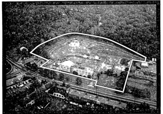

The first image depicts the site back when it was used for the extraction of Thorium along with other metals. In the second image we see how the site looks today as a dog park, which starts from the fence and goes further into the photo. What makes these two images particularly valuable is that they show how the site and its surroundings looked then and how it looks today, which helps us understand to what extent the site has changed and the various parties affected by the site and its history.
As for the first photo, I went to the Wayne Public Library and was given access to the FURSAP/WISS portfolio, in which I stumbled upon this image among others. This image was taken from an aerial view, possibly by a government institution sent to survey the area. It is of very poor quality, indicating that it was probably taken in the beginning of the investigation/survey procedure.
In this photo we can see that the now-busy commercial area was once quiet and rural. The site has its borders highlighted. Across the site we can see big barn-like buildings. These buildings could possibly have been for the cows originally, but over time may have been used by companies like W.R. Grace for storage or other purposes. It is also possible that these building are the houses of the “residents of the area, many of whom moved into housing tracts built in old cow pastures in the early 1960’s…”[19]
I am the photographer who took the second photo. I decided to create my own image rather than use an available image from the internet or some other source because I couldn’t find an image that did the site enough justice. I took the image recently, in March 2019. At this time there was no construction going on in the image, everything was functioning as it usually would; the dog park was open and active. I wanted to take my knowledge of the site’s surroundings as a Wayne local and communicate that knowledge to the general public, through this image. None of the images I found of the site online did a good enough job of showing the surrounding businesses, lands, and residences.
When an observer first looks upon the image, he notices the trees and the dog park. What is particularly striking about the dog park is how nice it looks. Even the park’s driveway looks very neat and clean. The design of the park itself looks very relaxing to the eye. The park was clearly designed in a clever manner, probably to make the scary looking fenced-off plot of land filled with overgrown weeds, carrying a dark history, into an attractive site for the locals to enjoy. It is even possible that by designing this site to look so attractive, the intent was to in turn make the area more attractive for real-estate and business. This assumption is strengthened by the fact that around the same time that the park was built a new Pharmacy opened up right across from the site and new set of houses were built right next to it, both of which are visible in the image. Through analyzing the attractive nature of the site, we can see how the site has been ‘re-advertised’ to the public.
It is worth noting that behind the trees at the end of the park, across the farm, there is a set of new houses. The houses lie next to the site with only a small distance separating the two. It is worth noting that these houses were built in 2012,[20] the same year in which the site was finally removed from the National Priorities List after a long clean-up and remedial process. This gives us hints on why these houses were built near the site. It is probable that the site caused the surrounding property to be cheaper, and that when the site was finally taken off the NPL, the cheap land was taken advantage of. The removal of the site from the NPL likely affected the local businesses as well, which can be seen in the left of the photo. One thing that stands out in the image is the red neon “Stone Cliff Cleaners” sign to the left. Attached to this building is another business, the newly opened Black Oak Ridge Pharmacy. These are only two of the various businesses that exist across the road from the site, making this area a commercial area in a sense. These businesses may be another sign of the cheaper land price in the area surrounding the site.
In the back left of the image an observer can see red farm buildings with white roofs. These buildings are part of the what was the old Kuehm Farm, today known as Farms view. This is a farm that has been around for over a century; it predates the toxic site. The farm lies downhill from the site, this means that when it rains, the farm gets hit by whatever the rain picked up from the site. One local with whom I spoke mentioned that the owners denied that any toxins reached the farm, yet he expressed that he found that hard to believe. He went on to explain that the tomatoes that the farm grew used to look deformed. The susceptible location of the farm and its existence before and throughout the duration of the toxic site’s presence in the area makes it a key affected party in the area.
This image is valuable because it shows the site today along with the different affected parties surrounding it. This feature of the image helps me connect my site to the understanding we developed in class of environmental inequality in the postwar United States, because we learned that when it comes to a harmful site, it is those around it who pay the toll, and ultimately it is those who are affected who must act to end the harm inflicted upon them.

The Location of the Wayne Interim Storage Site with a 1-Mile Buffer
868 Black Oak Ridge Rd. Wayne, N.J. U.S.A 07470

The 2012-2016 ACS Summary Report
Data Table
2010 Census Report
The EJ Screen Map above depicts the location of the Wayne Interim Storage Site (WISS) with part of a 1-mile buffer I placed around it. What is significant about this map is that it shows a number of key landmarks that were affected by the harmful practices that occurred on the site. One landmark that stands out is the farm, downhill, right across the street from the site, titled, ‘Passaic County Farm.’ This farm predates the WISS by approximately a century. However, after W.R. & Grace moved into the neighborhood and the radioactive contamination it caused was discovered, the family that owned the farm had to take measures to ensure that their land was clean. Another landmark is the small ‘Pompton River Tributary.’ I hypothesized that this tributary was actually none other than the infamous Sheffield Brook. The same brook that became known for being polluted by the radioactive waste that flowed into it from the storm sewer that W.R. Grace used to dump liquid waste from its operations on the WISS. The sad thing is that this brook was ordinally used by the Sheffield family as a water source for the cows on their pasture (the original use of the location that became the WISS). To make matters worse, the brook used to flow into the Pompton river, which can also be seen on the above map, to the west. This brook according to Brian Twohig, the mechanic who works on the property attached to the WISS location, was paved over and was forgotten about. This may be the reason why I had so much trouble finding the brook on the map. Brian informed me that even today, when there is rainfall the brook remerges. I actually visited Brian’s shop on a rainy day and he took me to the forest behind his shop and showed me the brook, which was clearly visible. I compared what Brian told and showed me with the above EJ Screen map and with a map from a New Jersey Institute of Technology thesis paper from the 1980s and I have concluded that the tributary in the EJ screen map is Sheffield Brook. The thesis paper contains a map of the immediate vicinity of the WISS and clearly labeled Sheffield brook. In the thesis paper, the brook extends further northeast and east, breaking off into two directions, resembling what I witnessed firsthand. The EJ Screen map depicts the tributary as starting off further southwest. This seems to be because of what Brian informed me of, that the brook was paved over and now only appears when it rains.
Other significant landmarks within a 1-mile radius include the ‘Point View Reservoir’ to the east and the Route 23 highway to the west. Route 23 might affect some of the pollution data I acquired from the EJScreen website. The map also shows the newly built Farmview Court, the small dead-end right above the farm across Black Oak Ridge Rd. The houses on Farmview Ct. were built in 2012, the same year the Wayne Superfund Site was taken off of the National Priorities List (NPL).
As for the bar graph above, I selected for three factors: traffic proximity, hazardous waste proximity, and wastewater discharge indicator. The graph shows traffic proximity as over the 50th percentile for the U.S., the state and the region. This is likely due to the nearby highway less than a mile to the west. This is significant for two reasons. For one the large amount of traffic in the area means more pollution, which must be kept in mind when reading the data on hazardous chemicals. The second reason that the large amount of traffic is important, is that a lot of people pass by this area throughout the week. This likely ties into how the W.R. Grace site was re-advertised to the public, as beautiful child and dog park in a commercial area. I selected for hazardous waste proximity for obvious reasons, to see how much the thorium and other radioactive chemicals that long plagued the site have an effect today. This category wasn’t that high, possibly due to the fact that the site witnessed a very long cleanup process. This process however never completely cleaned the site of the radioactive waste. The exact locations of the buried thorium were lost, and as a result the agencies involved in the clean-up had to estimate the locations and search for them. Brian informed me that there still remains buried thorium under the traffic light of Black Oak Ridge Road. He informed me that the government never got around to close the road in order to clean up the thorium buried under it. Lastly, I selected the wastewater discharge indicator because W.R. Grace didn’t only bury the waste but also dumped it into the storm sewer, thereby contaminating the connected waterways. The wastewater discharge indicator is pretty high, over the 70th percentile for the U.S., the state and the region. This is significant because it indicates that the water is still very unclean. The wastewater discharge indicator for the state was in the 86th percentile. This may be due to the waste the W.R. Grace site left behind. It also may be due to other reasons such as the busy roads and the highway. I still suspect that part of the pollution in the water that remains today is still from the radioactive waste left behind by W.R. Grace because the site and its surroundings were never fully cleaned.

A Map Depicting the Original Location of Sheffield Brook[21]
W.R. Grace’s unethical practices and failure to properly control its operations in extracting thorium led to the pollution of a the peaceful town of Wayne, New Jersey. It was the civilians who had to act quick to deal with the issue and it took serious governmental involvement to clean up the site. We can still see the effects of W.R. Grace’s operations in how the site was re-advertised as a beautiful park for people and their dogs as well as the new unit of houses right next to the site. This experience should serve as a reminder to both large corporations and civilians, that they should deal with the environment with more caution.
Endnotes
- U.S. Department of Energy, “Legacy Management FUSRAP Wayne, New Jersey, Site Fact Sheet,” November 2018, 1.
- Robert Hanley, “Waste from Atomic Research Found Contaminating Stream in Jersey Town,” The New York Times, June 8, 1983, 2.
- Farms View, “About the Farm,” https://farmsview.com/about-farms-view-new-jersey/.
- Lisa Fetterman Voyce, “The Manhattan Project Legacy,” New Jersey Institute of Technology, 1984, 18. For this source I use the pdf page numbers rather than the original page numbers of the thesis because certain pages at the start of the text have no page number in the original.
- U.S. Department of Energy, “Legacy Management FUSRAP Wayne, New Jersey, Site Fact Sheet,” November 2018, 1. According to the fact sheet, W.R. Grace took over in 1957. The NJIT thesis paper provides a different year 1956. I chose to go with the fact sheet because it was produced by the national government.
- “A Story of Innovation and Change,” Grace, https://grace.com/en-us/history/Pages/grace-history.aspx.
- Lisa Fetterman Voyce, “The Manhattan Project Legacy,” New Jersey Institute of Technology, 1984, 20.
- R.M. Howard, “Post-Remedial Action Report for the Wayne Site – 1985 and 1987,” FUSRAP, March 1989, 4.
- U.S. Department of Energy, “Legacy Management FUSRAP Wayne, New Jersey, Site Fact Sheet,” November 2018, 1.
- R.M. Howard, “Post-Remedial Action Report for the Wayne Site – 1985 and 1987,” FUSRAP, March 1989, 5.
- Robert Hanley, “Waste from Atomic Research Found Contaminating Stream in Jersey Town,” The New York Times, June 8, 1983, 5.
- Lisa Fetterman Voyce, “The Manhattan Project Legacy,” New Jersey Institute of Technology, 1984, 18-19.
- Robert Hanley, “Waste from Atomic Research Found Contaminating Stream in Jersey Town,” The New York Times, June 8, 1983, 5.
- “Radiological Survey of the W.R. Grace Property Wayne, New Jersey,” Radiological Site Assessment Program, January 1983, 3.
- Robert Hanley, “Waste from Atomic Research Found Contaminating Stream in Jersey Town,” The New York Times, June 8, 1983, 4.
- Lisa Fetterman Voyce, “The Manhattan Project Legacy,” New Jersey Institute of Technology, 1984, 12.
- U.S. Department of Energy, “Legacy Management FUSRAP Wayne, New Jersey, Site Fact Sheet,” November 2018, 2.
- U.S. Department of Energy, “Legacy Management FUSRAP Wayne, New Jersey, Site Fact Sheet,” November 2018, 2.
- Robert Hanley, “Waste from Atomic Research Found Contaminating Stream in Jersey Town,” The New York Times, June 8, 1983, 2.
- “2 Farm View Ct Wayne NJ 07470,” Zillow, Inc., https://www.zillow.com/homedetails/2-Farm-View-Ct-Wayne-NJ-07470/120802707_zpid/
- Lisa Fetterman Voyce, “The Manhattan Project Legacy,” New Jersey Institute of Technology, 1984, 16.
Bibliography
“A Story of Innovation and Change.” Grace. https://grace.com/en-us/history/Pages/grace-history.aspx.
“2 Farm View Ct Wayne NJ 07470.” Zillow, Inc. https://www.zillow.com/homedetails/2-Farm-View-Ct-Wayne-NJ-07470/120802707_zpid/
U.S. Department of Energy. “Legacy Management FUSRAP Wayne, New Jersey, Site Fact Sheet.” November 2018.
Robert Hanley. “Waste from Atomic Research Found Contaminating Stream in Jersey Town.” The New York Times. June 8, 1983.
R.M. Howard. “Post-Remedial Action Report for the Wayne Site – 1985 and 1987.” FUSRAP. March 1989.
“Radiological Survey of the W.R. Grace Property Wayne, New Jersey.” Radiological Site Assessment Program. January 1983.
Lisa Fetterman Voyce. “The Manhattan Project Legacy.” New Jersey Institute of Technology. 1984.
Primary Sources:
Primary Source 1
Title: Post-Remedial Action Report for the Wayne Site –– 1985 and 1987
Location: http://projects.wsj.com/waste-lands/site/525-wayne-site/
Description: This report alone, contains a plethora of raw data and professional analysis on my site, the Wayne FUSRAP site. Some of the information is easy to comprehend while some of it is more complicated. Nonetheless, this source is priceless for my research. This report contains a history of the site, some of the measures that were taken to clean up the site, along with statistics on the amount of radiation in the soil and various maps. In addition, this report mentions what had yet to be fulfilled, in terms of clean-up, in order for the site to have been no longer deemed a FUSRAP site, as of the 1980s.
Source is long here is link: http://projects.wsj.com/waste-lands/site/525-wayne-site/ (open doc with title NJ. 16-3)
Primary Source 2
Title: Radiological Survey of the W.R. Grace Property. Wayne, New Jersey. Final Report. January 1983.
Location: http://projects.wsj.com/waste-lands/site/525-wayne-site/
Description: This early report is very interesting. It contains an unusual history of the site and it mentions a fire in the 70s in which important information on the exact locations of the toxic dumps, was lost. The report then discusses in detail the sampling that was conducted on the site. The most interesting feature of this particular report is that it provides a detailed analysis of where the toxins went from the actual dump site. One example mentioned is how one of the companies that operated on the site would release liquids into a storm sewer system that would lead to the Pompton River. This detailed analysis of how the toxins were formed and where they ended up along with amazing maps of the region make this source particularly valuable.
Document is too long. Here is the link: http://projects.wsj.com/waste-lands/site/525-wayne-site/ (Open the document titled: NJ.16-8)
Primary Source 3
Title: United States Atomic Energy Commission Application for Source Material License (W.R. Grace & Co. Davison Chemical Division)
Location: http://projects.wsj.com/waste-lands/site/525-wayne-site/ (Doc NJ.16-5)
Description: This is a very interesting old document from the 1950s. It is an application filled out by W.R. Grace & Co., the company that polluted the Wayne Site. This application contains interesting details such as significant dates of when the application was docketed and when it expired, as well as information regarding the renewal of the license. This document also mentions for what the desired source material was going to be used for (in this case the document reads “Thorium Ore Processing”).
Secondary Sources:
Secondary Source 1
“Legacy Management Fact Sheet FUSRAP Wayne Site”. U.S. Department of Energy. 2000s.
This is a fact sheet on my site, prepared by the U.S. Department of Energy on or after 2012.
Description: This fact sheet contains a map and a legal history of what occurred to my Wayne site. What makes this fact sheet a useful source is that it is made by the federal government after the clean-up and transformation of the site. This means that it is both accurate and relevant. This source can help me keep my research in perspective.
Secondary Source 2
Hubbard, Daniel. “Superfund Site Removed from National List”. Patch. 2012. This is an online news article from the time in which my site was finally removed from the FUSRAP list.
Description: This article is particularly useful because it makes mention of the struggle of the local community to get the site cleaned up. It is also useful because it is from the same time period in which the site was removed from the Nation Priorities list. This article is sure to help me in keeping track of the struggle of the local population against the big corporation that polluted the area.
Secondary Source 3
Chi, Sheena. “W.R. Grace & Co. – Wayne Interim Storage Site (WISS)”. Flickr. 2010. This Flickr post contains sections from various sources on the Wayne Site.
Description: This Flickr page covering my site contains interesting information from various sources, some of which have been taken down from the net. I can use this source to search for other primary and secondary sources in person (i.e. from the U.S. Dept. of Energy or the Wayne Municipal Building).
Image Analysis:

This image depicts the Wayne Friends and Family Park in the foreground, a dog park that stands on what was once a toxic site, and its surroundings in the background. The site was use by the company W.R. & Grace for the extraction of Thorium ore and other rare earth metals. Toxic waste was buried on site and eventually contaminated the site and surrounding areas. Once the higher than normal levels of radiation were discovered, the EPA placed the site on the National Priorities list and the U.S. Department of Energy initiated a clean-up process. The clean-up was concluded in the year 1993 and the site and its surrounding areas continued to undergo remedial action. The site was officially removed off of the National Priorities List in 2012 and has been transformed into a dog park. What makes this image particularly valuable is that it shows the site today and the properties immediately surrounding the it, which helps me understand the various parties affected by the site and its history.
I am the photographer who took this photo. I decided to create my own image rather than use an available image from the internet or some other source because I couldn’t find an image that did the site enough justice. I took the image recently, in March 2019. At this time there was no construction going on in the image, everything was functioning as it usually would; the dog park was open and active. I wanted to take my knowledge of the site’s surroundings as a Wayne local and communicate that knowledge to the general public, through this image. None of the images I found of the site online did a good enough job of showing the surrounding businesses, lands, and residences.
When an observer first looks upon the image, he notices the trees and the dog park. What is particularly striking about the dog park is how nice it looks. Even the park’s driveway looks very neat and clean. The design of the park itself looks very relaxing to the eye. The park was clearly designed in a clever manner, probably to make the scary looking fenced-off plot of land filled with overgrown weeds into an attractive site for the locals to enjoy. It is even possible that by designing this site to look so attractive, the intent was to in turn make the area more attractive for real-estate and business. This assumption is strengthened by the fact that around the same time that the park was built a new Pharmacy opened up right across from the site and new set of houses were built right next to it, both of which are visible in the image. Through analyzing the attractive nature of the site, we can see how the drastic change that the site went through affected the surrounding area.
Another feature that stands out when one looks at the image is the set of new houses and the businesses in the background. The houses lie right next to the site with only a small distance separating the two. It is worth noting that these houses were built in 2012, the same year in which the site was finally removed from the National Priorities List after a long clean-up and remedial process. This gives us hints on why these houses were built near the site. It is probable that the site caused the surrounding property to be cheaper, and that when the site was finally taken off the NPL, the cheap land was taken advantage of. The removal of the site from the NPL likely affected the local businesses as well. One thing that stands out in the image is the red neon “Stone Cliff Cleaners” sign to the left. Attached to this building is another business, the newly opened Black Oak Ridge Pharmacy. These are only a two of the various businesses that exist across the road from the site, making this area a commercial area. These businesses may be another sign of the cheaper land price in the area surrounding the site.
In the back left of the image an observer can see red farm buildings with white roofs. These buildings are part of the what was the old Kuehm Farm, today known as Farms view. This is a farm that has been around for over a century; it predates the toxic site. The farm lies downhill from the site, this means that when it rains, the farm gets hit by whatever the rain picked up from the site. One local with whom I spoke mentioned that the owners denied that any toxins reached the farm, yet he expressed that he found that hard to believe. He went on to explain that the tomatoes that the farm grew used to look deformed. The susceptible location of the farm and its existence before and throughout the duration of the toxic site makes it a key affected party in the area.
This image is valuable because it shows the site today along with the different affected parties surrounding it. This feature of the image helps me connect my site to the understanding we developed in class of environmental inequality in the postwar United States, because we learned that when it comes to a harmful site, it is those around it who pay the toll, and ultimately it is those who are affected who must act to end the harm inflicted upon them.
Data Analysis:

868 Black Oak Ridge Rd. Wayne, N.J. U.S.A 07470

The EJ Screen Map above depicts the location of the Wayne Interim Storage Site (WISS) with part of a 1-mile buffer I placed around it. What is significant about this map is that it shows a number of key landmarks that were affected by the harmful practices that occurred on the site. One landmark that stands out is the farm, downhill, right across the street from the site, titled, ‘Passaic County Farm.’ This farm predates the WISS by approximately a century. However, after W.R. & Grace moved into the neighborhood and the radioactive contamination it caused was discovered, the family that owned the farm had to take measures to ensure that their land was clean. Another landmark is the small ‘Pompton River Tributary.’ I hypothesized that this tributary was actually none other than the infamous Sheffield Brook. The same brook that became known for being polluted by the radioactive waste that flowed into it from the storm sewer that W.R. Grace used to dump liquid waste from its operations on the WISS. The sad thing is that this brook was ordinally used by the Sheffield family as a water source for the cows on their pasture (the original use of the location that became the WISS). To make matters worse, the brook used to flow into the Pompton river, which can also be seen on the above map, to the west. This brook according to Brian Twohig, the mechanic who works on the property attached to the WISS location, was paved over and was forgotten about. This may be the reason why I had so much trouble finding the brook on the map. Brian informed me that even today, when there is rainfall the brook remerges. I actually visited Brian’s shop on a rainy day and he took me to the forest behind his shop and showed me the brook, which was clearly visible. I compared what Brian told and showed me with the above EJ Screen map and with a map from a New Jersey Institute of Technology thesis paper from the 1980s and I have concluded that the tributary in the EJ screen map is Sheffield Brook. The thesis paper contains a detailed hand-drawn map of the immediate vicinity of the WISS and clearly labeled Sheffield brook. In the thesis paper, the brook extends further northeast and east, breaking off into two directions, resembling what I witnessed firsthand. The EJ Screen map depicts the tributary as starting off further southwest. This seems to be because of what Brian informed me of, that the brook was paved over and now only appears when it rains.
Other significant landmarks within a 1-mile radius include the ‘Point View Reservoir’ to the east and the Route 23 highway to the west. Route 23 might affect some of the pollution data I acquired from the EJScreen website. The map also shows the newly built Farmview Court, the small dead-end right above the farm across the street. The houses on Farmview Ct. were built in 2012, the same year the WISS was taken off of the National Priorities List (NPL).
As for the bar graph above, I selected for three factors: traffic proximity, hazardous waste proximity, and wastewater discharge indicator. The graph shows traffic proximity as over the 50th percentile for the U.S., the state and the region. This is likely due to the nearby highway less than a mile to the west. This is significant for two reasons. For one the large amount of traffic in the area means more pollution, which must be kept in mind when reading the data on hazardous chemicals. The second reason that the large amount of traffic is important, is that a lot of people pass by this area throughout the week. This likely ties into how the W.R. Grace site was re-advertised to the public, as beautiful child and dog park in a commercial area. I selected for hazardous waste proximity for obvious reasons, to see how much the thorium and other radioactive chemicals that long plagued the site have an effect today. This category wasn’t that high, possibly due to the fact that the site witnessed a very long cleanup process. This process however never completely cleaned the site of the radioactive waste. The exact locations of the buried thorium were lost, and as a result the agencies involved in the clean-up had to estimate the locations and search for them. Brian informed me that there still remains buried thorium under the traffic light of Black Oak Ridge Road. He informed me that the government never got around to close the road in order to clean up the thorium buried under it. Lastly, I selected the wastewater discharge indicator because W.R. Grace didn’t only bury the waste but also dumped it into the storm sewer, thereby contaminating the connected waterways. The wastewater discharge indicator is pretty high, over the 70th percentile for the U.S., the state and the region. This is significant because it indicates that the water is still very unclean. The wastewater discharge indicator for the state was in the 86th percentile. This may be due to the waste the W.R. Grace site left behind. It also may be due to other reasons such as the busy roads and the highway. I still suspect that part of the pollution in the water that remains today is still from the radioactive waste left behind by W.R. Grace because the site and its surroundings were never fully cleaned.
The 2012-2016 ACS Summary Report
Data Table
2010 Census Report
Oral Interviews:
Video Story: