The Most Irradiated Spot on Earth and the Injustice Done There
by Benjamin Richards
Site Description:
Lake Karachay is a 0.15 km2 body of water located in the city of Ozersk, in the Ural Mountain region of the Russian Federation (55.6781° N, 60.7996° E). In 1951, the Mayak Production Association, a weapons-grade plutonium production site, used the lake as a convenient dumping spot for radioactive waste. Overseen by NKVD Chief Lavrenti Beria, under Stalinist decree to develop enough plutonium in order to match the US’s nuclear advantage. The lake stopped being used as a dumping site when an incident in 1957 caused underground storage sites to explode. The people living in the city and nearby villages were not told of the dumping due to security concerns of the Soviet government. The true tragedy occurred in 1968 when a drought caused part of the lake to dry up and still highly radioactive material was blown all over the region, irritating about 500,000 people
Final Report:
In the Ural Mountains region of Russia, there exists a lake that is so highly irradiated that being exposed to it for merely an hour will lead to death. This lake was the site of an environmental injustice that went on from 1948 to 1957.[1] During those 9 years, the lake was part of a secret Soviet nuclear project that resulted in thousands of cases of radiation poisoning, cancers, and deaths of the people living in the area.[2] For the most part, the people were completely unaware of the goings on at this lake or the existence of the plutonium production site close by.[3] The name of the lake is Lake Karachay, and the company responsible for the goings on there is Proizvodstvennoye ob′yedineniye “Mayak”, meaning Mayak Production Association in English.
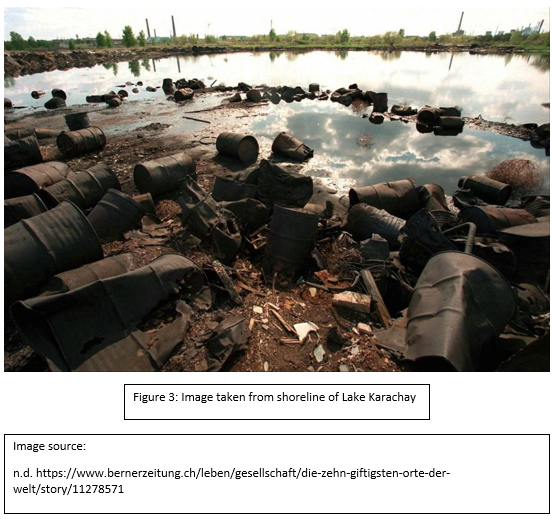
Today, Lake Karachay is located within the grounds of the Mayak Production Association production site just inside the limits of the city of Ozersk which resides in the Chelyabinsk Oblast (tran: “Oblast” → administrative division or region) of the Ural Mountains region of the Russian Federation (55°40′42″N 60°47′59″E).[4] Figure 3 is an image taken from the side of the lake. The lake is about 0.15 km2 in area and has an average depth of about 1.25 meters.[5] Nothing lives in this lake do to the 4.44 EBq of radioactivity that emanates from the lake.[6] Due to the size of the lake, this means the Lake Karachay has the single highest radioactivity concentration then anywhere on Earth.[7]
Lake Karachay became like this due to the operations of the Mayak Production Association in the years just after the second world war. As everyone knows, the latter half of the 20th century saw the United States of America and the Union of Soviet Socialist Republics in a competition for world dominance. After the use of atomic weapons at the end of the war, the world came to the realization that nations that held these weapons in their arsenals would have a diplomatic advantage. This led both superpowers to start mass producing large stockpiles of these devices.
Nuclear weapons usually need a core of Plutonium to begin the critical mass reaction. Plutonium is not a naturally accruing element and is very difficult, dangerous, and time consuming to produce. The specific isotope of Plutonium used as the core is Plutonium-239. It requires a nuclear reactor to transmute common Uranium-238 into the Uranium-239 isotope through neutron bombardment. The Uranium-239 must than undergo 2 b decays. The result is the Plutonium-239 isotope. The problem being that the Plutonium-239 is mixed in with a lot of other highly radioactive elements and there is not much actually made. This makes this type of plutonium very hard to come by.[8]
Desperate to get on an even playing field with the United States’ nuclear stockpile, a plan was hastily made to produce the Plutonium-239. Under Stalinist decree, the Mayak Production Association was created in 1948 order to produce the Plutonium needed. It had been determined that the best place to build their production site was in an isolated area of the Ural Mountains. This was to limit the potential radioactive exposure to people.
However, the area was not completely uninhabited. Some villages of about 28,000 people lived by the Techa River.[9] The Techa River flows from Lake Kyzyltash, which is where the Mayak Production Association decided to build their plant next to. Figure 1 shows the extent of the Techa River. The Mayak Production Association decided in order to support their plant to also build a city in order to house the workers of the plant.[10] At the time the city was called Chelyabinsk-40 and now the city of Ozersk.
Construction of the city and plant was started in 1945 and the construction labor force consisted of 40,000 Gulag prisoners and POWs.[11] The production of the plutonium started in December 1948. During operations, workers were not informed of the danger of the material they were handling or how to avoid risks.[12]
Operations were very production focused and little thought was given to safety or to the radioactive waste that was a byproduct of the production. The design of the plant itself had little concern to any environmental damage it could do. Workers and people living in the nearby city were constantly exposed to radiation due to improper equipment being used.[13]
The plant’s reactors required large amounts of cooling. The Mayak Production Association, had planned for this in advance and the plant was built right next to Lake Kyzyltash to use the lake as a source of coolant.[14] The design of the reactors used by the Mayak Production Association was an open-cycle cooling system for their reactors. That means the water that passes over the uranium-graphite fuel rods gets dumped right back into the lake. The 40 villages around the Techa River were in danger because of this because Lake Kyzyltash drains into the Techa river. Figure two shows this in more detail.
The people of these villages ended up getting highly irradiated and several deaths occurred.[15] Figure 4 shows the extent of the damage that was done to this. This would seem like an obvious problem and it must be an over-site, but Dr. Mira M. Kosenko, a medical doctor who treated victims in the villages, found out otherwise.
In Dr. Mira M. Kosenko’s technical report to the Defense Threat Reduction Agency, Where Radiobiology Began in Russia: A Physician’s Perspective, she discusses her findings when trying to determine how these people ended up getting so irritated. She found that the people had been using the river for drinking water. When she confronted bureaucrats from the USSR atomic ministry, the origination that over saw the goings on of the USSR’s nuclear weapons development, she was told that “there was no accident” (Kosenko, 2010) at the Mayak Production Association production site.[16] According to Dr. Mira M. Kosenko, the bureaucrats wanted to avoid using the word “mistake”. It would imply that something had not gone according to plan.[17] This would imply that the contaminating of the river was completely intentional. Dr. Mira M. Kosenko further quarried them: ‘“You knew what this would lead to and you discharged anyway? Why didn’t you at least dig wells in the villages?”’ (Kosenko, 2010). The bureaucrat’s response was: ‘“We hoped that it would all be diluted by water and would be insignificant, imperceptible.”’ (Kosenko, 2010). The water had not diluted the radioactivity. The Norwegian environmental organization had found traces of the radioactive materials as far as the Arctic Ocean.[18]
However, the Mayak Production Association had put the most highly radioactive waste elsewhere. Since the plants own hazardous material storage location was not adequate to store these materials, an alternate storage location had to be used. The alternate storage space was Lake Karachay. the lake became a dumping spot for years. And over the years it was used, it became the single most contaminated spot on earth.[19]
The lake was a poor holding spot. Years after it was disused the radiation still persisted there. Over time the water began to evaporate from the lake. In 1968 a particularly dry season cased the lake to evaporate extensively. The radioactive sediments in the lake bead were now exposed to the air. Wind then carried the radioactive material all over the Chelyabinsk Oblast. About 500,000 people were irradiated from this.[20]
The crimes of Mayak Production Association are quite apparent due to their extreme disregard of human and environmental safety.


[1] “Mayak Production Association.” Nuclear Threat Initiative, May, 13, 2014, https://www.nti.org/learn/facilities/894/
[2] Degteva, Anspaugh, Vasilenko “Mayak Production Association: Introduction.” Radiation and Environmental Biophysics 41 (1): 19-22.
[3] “Nuclear History – the forgotten disasters” nuclear-news, https://nuclear-news.net/information/nuclear-history/nuclear-history-the-forgotten-disaster/
[4] A. Aarkrog, H. Dahlgaard, S.P. Nielsena, A.V. Trapeznikovb, I.V. Molchanovab, V.N. Pozolotinab, E.N. Karavaevab, P.I. Yushkovb, G. G. Polikarpov, “Radioactive inventories from the Kyshtym and Karachay accidents: estimates based on soil samples collected in the South Urals (1990-1995)”, The Science of the Total Environment (1997)
[5] Merkushkin, Alexey, KARACHAY LAKE IS THE STORAGE OF THE RADIOACTIVE WASTES UNDER OPEN SKY, Ozyorsk Technological Institute of Moscow (Russia)
[6] Pike, J, “Chelyabinsk-65 / Ozersk”, WMD Information – GlobalSecurity.org, https://www.globalsecurity.org/wmd/world/russia/chelyabinsk-65_nuc.htm
[7] Lenssen, “Nuclear Waste: The Problem that Won’t Go Away”, Worldwatch Institute, (1991): 15.
[8] “Plutonium-239 formation”, RADIOACTIVITY.EU.COM, https://www.radioactivity.eu.com/site/pages/Plutonium_239_Formation.htm
[9] Burmistrov, Kossenko, Wilson, Radioactive Contamination of the Techa River and its Effects, Harvard University
[10] Kate Brown, Plutopia: Nuclear Families, Atomic Cities, and the Great Soviet and American Plutonium Disasters (Oxford University Press, 2013)
[11] Kate Brown, Plutopia: Nuclear Families, Atomic Cities, and the Great Soviet and American Plutonium Disasters (Oxford University Press, 2013)
[12] Mira M. Kosenko, Where Radiobiology Began in Russia: A Physician’s Perspective (Fort Belvoir: Defense Threat Reduction Agency, 2010)
[13] Degteva, Anspaugh, Vasilenko “Mayak Production Association: Introduction.” Radiation and Environmental Biophysics 41 (1): 19-22.
[14] “Mayak Production Association.” Nuclear Threat Initiative, May, 13, 2014, https://www.nti.org/learn/facilities/894/
[15] Mira M. Kosenko, Where Radiobiology Began in Russia: A Physician’s Perspective (Fort Belvoir: Defense Threat Reduction Agency, 2010)
[16] Mira M. Kosenko, Where Radiobiology Began in Russia: A Physician’s Perspective (Fort Belvoir: Defense Threat Reduction Agency, 2010)
[17] Mira M. Kosenko, Where Radiobiology Began in Russia: A Physician’s Perspective (Fort Belvoir: Defense Threat Reduction Agency, 2010)
[18] Mira M. Kosenko, Where Radiobiology Began in Russia: A Physician’s Perspective (Fort Belvoir: Defense Threat Reduction Agency, 2010)
[19] “Mayak Production Association.” Nuclear Threat Initiative, May, 13, 2014, https://www.nti.org/learn/facilities/894/
[20] Pike, J, “Chelyabinsk-65 / Ozersk”, WMD Information – GlobalSecurity.org, https://www.globalsecurity.org/wmd/world/russia/chelyabinsk-65_nuc.htm
Bibliography
n.d. https://www.bernerzeitung.ch/leben/gesellschaft/die-zehn-giftigsten-orte-der-welt/story/11278571.
Brown, Kate. 2013. Plutopia: Nuclear Families, Atomic Cities, and the Great Soviet and American Plutonium Disasters. Oxford University Press.
Burmistrov, Dmitriy, Mira Kossenko, and Richard Wilson. n.d. “Radioactive Contamination of the Techa River and its Effects.” Department of Physics, Harvard University, Cambridge. http://wilsonweb.physics.harvard.edu/publications/pp747/techa_cor.htm.
Degteva, Anspaugh, and Vasilenko. 2002. “Mayak Production Association: Introduction.” Radiation and Environmental Biophysics (Springer-Verlag) 41 (1): 19-22. doi:10.1007/s00411-002-0148-5.
GlobalSecurity.org. n.d. “Chelyabinsk-65 / Ozersk.” https://www.globalsecurity.org/wmd/world/russia/chelyabinsk-65_nuc.htm.
Karaketov, M. D. 2014. Karačaevcy. Balkarcy. Moskva: Nauka.
Kosenko, Mira M. 2010. Where Radiobiology Began in Russia: A Physician’s Perspective. Technical Report, Defense Threat Reduction Agency, Department of Deffence, Fort Belvoir: United States Goverment.
Lenssen, Nicholas K. 1991. Nuclear waste: the problem that won’t go away. Washington, D.C.: Worldwatch Institute
2014. “Mayak Production Association.” Nuclear Threat Initiative, May 13. https://www.nti.org/learn/facilities/894/.
nuclear-news. n.d. “Nuclear History – the forgotten disasters.” https://nuclear-news.net/information/nuclear-history/nuclear-history-the-forgotten-disaster/.
Rieke, Jan. 2010. “Satellite image/map of the Mayak nuclear facility.” NASA World Wind screenshot (Landsat Global Mosaic visual layer), April 30. https://commons.wikimedia.org/wiki/File:Satellite_image_map_of_Mayak.jpg.
n.d. “Techa River: Nuclear disaster along the Techa River (Southern Urals, Russia).” Kyoto University, Kyoto. http://www.rbc.kyoto-u.ac.jp/db/Literature/Techa%20River.html.
Primary Sources:
Source 1
Title: Where Radiobiology Began in Russia: A Physician’s Perspective
Location: Click to access ADA535346.pdf
Description: The report contains the findings of Dr. Mira M. Kosenko, who treated victims Kyshtym Incident. The report also has firsthand accounts of the victims. The information here will be useful to understand the events of the Incident.
Citation: Kosenko, M. M. (2010). Where Radiobiology Began in Russia: A Physician’s Perspective (Rep.). Fort Belvoir, VA: Defense Threat Reduction Agency. doi:https://apps.dtic.mil/sti/pdfs/ADA535346.pdf
Source 2
Title: Analysis of Chronic Radiation Sickness Cases in the Population of the Southern Urals
Location: Click to access ADA286238.pdf
Description: The report contains medical data from people 40 years after they were exposed to radiation from leaks from the Mayak Production Association. This will give a better understanding of how the people exposed to the radiation have been affected.
Citation: Kossenko, M. M., Akleyev, A. A., Degteva, M. O., Kozheurov, V. P., & Degtyaryova, R. G. (1994). Analysis of Chronic Radiation Sickness Cases in the Population of the Southern Urals (Rep. No. CR 94-1). Bethesda, MD: Armed Forces Radiobiology Reaserch Institute. doi: https://apps.dtic.mil/sti/citations/ADA286238.pdf
Source 3
Title: Radioactive inventories from the Kyshtym and Karachay accidents: estimates based on soil samples collected in the South Urals (1990-1995)
Location: https://www.sciencedirect.com/science/article/pii/S0048969797000983?via=ihub
Description: The report contains data from soil taken in and around Lake Karachay. The samples will show what exact radioactive isotopes the people were irradiated with.
Secondary Sources:
“The Most Contaminated Place on Earth: Chelyabinsk-40 | Sometimes Interesting.” Sometimes Interesting, Sometimes Interesting, 15 July 2011, https://sometimes-interesting.com/2011/07/15/the-most-contaminated-place-on-earth-chelyabinsk-40/.
This is an article about the lake, surrounding area, and the condition of the environment there.
This source will help me because it provides information on the area and how the disaster of Lake Karachay came to be, such as the names of the areas that were affected and the name of the company that caused the disaster. It also has information on the disaster itself, and witness accounts of the outcome. One of the witnesses is Dr. Mira M Kosenko, who is treated and studied the victims of disaster, is the author of a primary source that I am using for this report.
Tugend, Alina. “LIVING UNDER A RADIOACTIVE TIME BOMB – Chicago Tribune.” Chicagotribune.Com, Chicago Tribune, 29 June 1993, https://www.chicagotribune.com/news/ct-xpm-1993-06-29-9306300330-story.html.
This is an article from the Chicago Tribune that goes step by step on why the events of the Lake Karachay happened.
This source will help me because it effectively provides a timeline that I can use to trace the events of the disaster. This article is also a lot older than my other secondary source so it can give me insight into how the perspective of the event has changed.
Image Analysis:

This image is a picture taken on one of the shore banks of Lake Karachy.
Lake Karachy was used as a dumping site for radioactive waste by the Mayak Production Association from 1951 to 1957. The radioactive material leaked into the lake and irradiated it and the surrounding area. The image shows several drums that could have been the same drums being used to transport the radioactive waste. The lack of human activity and lack of wildlife in the image may be a result of the radiation. Also, the lack of vegetation in the body of water and on the shoreline in proximity to the drums suggests that living things can not stay close to these entities.
This body of water shows signs of being deeper at some point. Looking at the top left corner of the image, it can be seen that the shoreline used to be quite a bit higher. Lake Karachy rapidly lost volume in a drought in 1968. Subsequently the exposed irritated lake sediment was blown by the wind all over the region. Lake Karachy is located just outside the city of Ozyorsk. The buildings on the horizon may be that city. The distance from were the picture was taken to the buildings is about correct distance Lake Karachy is from the closest buildings according to Google maps. Additionally, the presence of tumble weeds in the image suggests that this may be Lake Karachy. Lake Karachy is located in the Ural Mountains, and tumble weeds are native to these mountains. The image has several tumble weeds in it, most promptly on the center right side of the image.