Are Parks Along Newtown Creek a Pollution Solution, or Another Problem?
by Jozy Bentley
Site Description:
Newtown Creek is a 3.5-mile body of water that runs along the border between Brooklyn and Queens in New York City. For over 150 years this creek has been labeled one of the most polluted industrial sites within the United States. Because the creek contains harsh chemicals, toxins, sewage, and oil the surface is 14ft in depth of sludge which kill the ecosystem in and out of the water. Humans are not the only one’s environmental injustice affects. Over the past few years, area’s such as Greenpoint, NY have been developing greenspaces within the old industrial zones that brings life back to the surrounding communities. However, this solution is not one for the bigger picture. It is simple a small step taken to give hope. Environmental groups have fought for these spaces in order to cunt down the pollution of the areas surrounding the creek and the creek itself but it does not stop the ongoing contamination of the creek. With these greenspaces also come underlying gentrification. Even though, the green space is a great idea, it eventually displaces those who are of middle/ lower class because of property inflation.
Final Report:
The forgotten New York
How no one can hear your blues
They built you up then tore you down
How could your people step on you?
Pumping water of rubbish
Breathing in your ancestors’ breath
And
None of it fresh
Vacant lots producing spaces for grass but not a place to call home
The people want to live
Long enough to give fresh air to their kids
Whose waters can turn to milk and make their economy strong.
Newtown Creek is a body of water that forms the border between the New York City boroughs of Brooklyn and Queens. People sometimes refer to this area as the forgotten New York. For over 150 years this creek has been labeled one of the most polluted industrial sites within the United States. Because the creek contains harsh chemicals, toxins, sewage, and oil the surface is about 14ft in the depth of sludge that kills the ecosystem in and out of the water. Humans are not the only living creatures that environmental injustices affect; our ecosystem becomes tainted by pollution just like us.[1]
Over the past few years, areas such as Greenpoint, NY has been developing green spaces within the old industrial zones to bring life back into the surrounding communities. However, this solution is not solving the problems of these communities; it just gives them a small token of hope. Environmental groups have fought for these spaces to cut down the pollution of the areas surrounding the creek and the creek itself, but it does not stop the ongoing contamination of the creek. With these greenspaces also come underlying gentrification.[2] Although parks are being built to clean up the areas around Newtown Creek, they are causing gentrification within the surrounding communities.
Due to this heavy pollution, some wonder if it is possible for Newtown Creek to be restored, or will parks be built that hide what is really happening in the creek? How has the development of these green recreational projects/parks contributed to the dispossession of those living in the area who are financially vulnerable or linguistically challenged? And how has gentrification played a role in the way this creek has been treated pre-industrial era to now?
The parks that are currently being developed along Newtown Creek, to clean up the areas, are a good idea. However, they do not solve the ongoing issue of pollution these boroughs and the body of water separating them face. Within this paper, you will understand the amount and type of pollution that has occurred within and around this project site. Starting with the pollution of Newtown Creek, the solution that is being developed such as greenspace/nature walks/parks, and how these developed solutions are not solving the environmental problems this creek and surrounding areas deal with.
Although parks are being built in effort to clean up the areas around Newtown Creek it is causing gentrification to become more evident within the surrounding communities. A superfund site has been established in order to make those who had and continue to pollute the Creek (ex: Exxon Mobil company); however, the developments that have taken place are causing for property taxes and the cost of living to rise in surrounding neighborhoods which is inhabited by mainly those of low income, linguistically challenged, and are considered a minority causing for the gentrification that already existed to take a different turn.[3]
History of Newtown Creek’s Pollution:
Before the industrial revolution, these waterways were used by farmers to import and export goods along the creek. Once the industrial revolution took place in the early 1800s this creek became an industrial waterway. About 50 manufacturing companies lined along the bank of the creek. These companies were oil refineries, petrochemical plants, fertilizer and glue factories, and sawmills, as seen in the map below.

Odor Producing Industries[4]
By the 1970s the state of New York determined that the water quality of this creek did not meet the standards that fell under the Clean Water Act. Due to the heavy water traffic, factory waste, and non-established sewage system within New York, the creek became quickly polluted along with the streets of New York. The street pollution amongst the boroughs consists of underground oil and human feces that people would toss out of their windows due to the none developed sewage systems. The effect this had on the communities were all health-related due to the unsanitary system they lived amongst.[5]The pollution within the creek and under the streets of Brooklyn and Queens became an issue after the installation of oil pumps, which were sponsored by Exxon Mobil/ BP in 1979. By 2006, the Department of Environmental Conservation asserted that the ExxonMobil refinery had leaked between 17 and 30 million gallons of oil into the soil and groundwater in Greenpoint, Brooklyn.10 This groundwater runs into the Newtown Creek which contributes to the existing pollution. The following are the 3 oil spills that are harming Newtown Creek: Manhattan Polybag, Morgan Oil, and Pratt Oil. Manhattan Polybag and Morgan Oil are former oil storage sites located in Greenpoint, Brooklyn, New York while Pratt Oil was a refinery, located in Queens, New York.[6]
Water Pollution:
Throughout history, industries have contributed to water and air pollution the most if not, alone. The pollution of water being an issue is important because this creek runs into a larger body of water called the East River. Also, when water levels rise in the creek, water spews onto nearby streets within surrounding neighborhoods due to poor storm drain and sewage systems. Industries have affected the water by leaking fuel from boats when transporting goods along the creek and oil refineries/storage facilities are also at fault for using the creek as a garbage bag and leaking chemicals into the water.[7]To compensate for the water pollution, there were treatment plants created in effort to clean up that creek. These plants included wastewater pumping stations that are utilized to remove contaminants and industrial waste from Newtown Creek. These plants along with the enforcement of the Clean Water Act ensure sanitary water to protect human health and maintain a clean environment. Also, allowing for residents to receive clean water into their homes. However, this does not solve a pollution problem when there are still factors contributing to the ongoing pollution to the water and air.[8]
Air Pollution:
The pollutant of the air is important because these industries also play a role in the long-time history of the increased toxins within the ozone layer above this site. Affecting communities more than the water, the water contributes to air pollution because the chemicals/gases in the water get evaporated into the air due to condensation. In seasons where there is warm weather, the process of water vapor becomes more frequent.
Air pollution affects all living things breathing and not breathing because of the toxins absorbed through condensation and smoke that comes from machines. The EJSCREEN website (see data below) says that out of 2,067 people a range of 1,964-2,067 suffer from respiratory issues due to air contamination. This means due to the constant exposure to air pollution; the elderly develops the need for respirators while others (children specifically) develop asthma. Having clean air to breath in is important to everyone’s health.[9]

How Newtown Creek’s Pollution Affects its People (Demographics):
Below are the EJSCREEN demographic indicators that correlate with the environmental factors. The three that are relevant to my study of Newtown Creek are: the minority population, low income status, and linguistically isolated populations. These demographic indicators correlate with the environment because it gives a little more information about what majority makes up this area’s population. With foreigners ranging from Polish-White, the majority does not always win. According to a 2010 census report a population of 1,622 existed and only 50% of this population is identified as a “minority”.6 Even now the population stays about the same but what does this mean for gentrification? Things are shaping up, gentrification is still among these areas, they are just considered “displaced”. The displacement of minorities simply means they are in an area like Greenpoint just relocated to another section that is usually affordable for them.[10]

These indicators are important to the history of Newtown Creek and the current situation because going from framing lands to industrial land helped shape the demographics of the area. Throughout history, historians have discovered that the condition of the land determines the type of inhabitants. Being that it was an industrial area that presented job opportunities that allowed many to take up positions within factories throughout the area. For example, when the potato famine happened in Ireland a lot of Irish families migrated to New York. The time could not have been better because this was around the same time factories were blooming and so was the work. However, even with job placements being a positive factor for the economy, it is these same industries that started the trail of pollution we can still see today.
Both indicator sectors have concluded that the environment and demographic go hand in hand with one another. Through this observation of data I have discovered that even though the majority of the industrial businesses within this industrial area have been relocated or shut down due to New York’s attempt to deindustrialize these areas, it is still very much populated and polluted by factories. The foundation of Brooklyn and Queens also play individual roles as well because of the crippling sewage systems and impromptu way of disposing of hazardous waste. Even though the 0.2 EJSCREEN buffer I placed along the Newtown Creek shows that these areas are populated by a lot of linguistically challenged minorities. This data is resourceful because it gives a possible reason as to why what was happening around these areas did happen due to a misunderstanding or interpretation of surrounding things. This data is resourceful because it gives a possible reason as to why the area is heavily polluted. These areas became polluted and remain contaminated due to the barrier that exists between understanding and reasoning.
Are Parks the Solution to Pollution?
Over the past decade New York has been taking the necessary first steps in cleaning up Newtown Creek and making surrounding areas eye appealing for communities. The development of these spaces is causing a non-noticeable problem for business owners and residents. Like any area, development usually leads to the incline of rent or property taxes. During the 1970s, for areas like Greenpoint, shootings and fights were a normal everyday experience people wentthrough.[11] With the landscapes around Newtown creek being abandoned factories and collapsing buildings. Many saw this as an opportunity as an investment and purchased some properties that later were transformed into housing condos.[12]
The effects that gentrification has on these areas are not only about the shrinkage of affordable housing and the rezoning of manufacturing areas, but it most importantly must deal with the displacement of the culture and ethnicity withinit.[13] With the development of condos, yes, the owner makes a prophet, but those who cannot afford it are forced to continue living in their current home until forced out of the area by rent inflation or because they can no longer afford the property taxes where they are. “Real estate agents have started to show the bar to potential buyers, knowing that a white outpost in a predominantly black neighborhood opens the mind forspeculation”.[14] This examination of what is happening in the communities can be seen throughout all of Brooklyn and Queens, New York. These places were once a place that people feared to roam around are now becoming the up and rising places for development, others are left with the options of selling and moving. Now it is the up and coming for artists and the new generations.
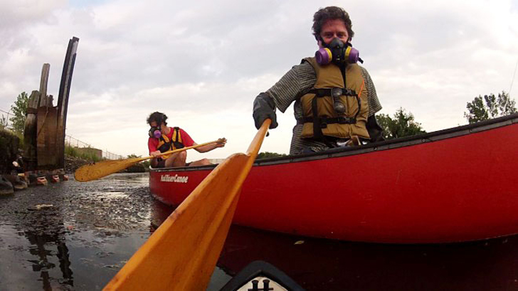
The image below was taken by Nathan Kensinger, who is a photographer, filmmaker, and curator that has been documenting New York City’s abandoned edges, endangered neighborhoods, and post-industrial waterfront for more than a decade.[15] He has published several articles and books based on the New York waterfront and the pollution that comes with it. This image and its analysis, done by myself, will allow you to explore the realization of the pollution this creek carries and how it is being examined/cleaned by people who seem to be non-natives of the area due to materialistic.

Nathan Kensinger (right), shot from the camera on one of the Newtown Creek Armada remote-controlled boats. 8 September 2012[16]
The intended audience for this photo was not only those fighting environmental injustice but for the artist as well. Being posted on a pollution art website, artists and those interested in art have been the ones drawn to this image. The first thing about this image I would like to discuss is the respiratory mask that the men are wearing. This is important because for the focus to be on the pollution of the water no one ever stops to think about the air that surrounds the creek and how it is just as polluted as the water. By wearing these masks while on a boat within the creek, it supports the notion that the air is just as polluted. This also connects to the lack of trees you can see in the background. Nature is present to help reverse the harm of humans due to the environment. However, in an area that is so highly polluted and lacks so many trees how the carbon in the air is supposed to be taken and reproduced as oxygen if there are not enough trees or plants to do the job.
Next is the gate you can see on the left side of the image. This gate raises many questions but also supports a lot of evidence as to just how polluted this area is. For instance, the Hudson River is known for its polluted waters; yet, you do not see them constructing huge gates around the river. For this creek, on the other hand, gates are put up to keep people and animals from going into the water, fishing, or (for animals) drinking. This would not have to be done as a precautionary measure if the water were somewhat safe. Instead, it must be done. When the weather is bad, and the creek overflows you can find people wearing protective gear trying to clean the garbage that comes up on to the streets. This brings us to the black water itself. The color of the water does a good job of showing how polluted this creek is. However, the debris you can see floating on top of the water shows a little of what one can find in the water.
My eyes are instantly drawn to the respiratory mask on the two guys’ faces. I believe this is my focal point because it paints a bigger picture of the toxins within the creek. Highlighting how the pollution in the creek does not only affect the water but the air that surrounds it.
Next, my eyes are drawn to the second guy in the background and then to the mercy water and lastly the paddle. I believe I am drawn to the second guy next because of how differently he dressed compared to the first guy. Then to the noticeable stuff floating on top of the dark water and the paddle because of its ability to seem as if it is reaching for me but instead is aiming at the camera capturing this moment.
In this image, the only activity seen is the one on the boat. However, in the background, you can tell that something is being prohibited due to the gates that section of the area. Then with the few trees in the background, it can symbol the industrial area this creek is in because with more buildings and zoning the less nature is made available.
When analyzing the colors this camera catches you notice from top to bottom the image goes from being light to dark. Starting with the black oily mayonnaise looking water which is lined with polluted muck. This is a great representation and capture of the effects of oil spills/leaks, PCB’s, heavy metals, and everything else on the visual image of the creek. Then as my eyes move upward, I notice the one guy (on the right) is dressed in dull tones and fully covered with protective gear. His dimmest represents the pollution bubble he is currently in is that he has on a respiratory mask and skin is fully covered. This could also be because he is a part of the community that this creek affects. Meanwhile, the other guy (on the left) is a little brighter and a lot less covered in protective gear. Although he still wears a respiratory mask his skin is exposed which could indicate that he is not from the nearby communities and does not know the effects of this polluted water. While the background is a little lighter yet there is no visible sun, this can indicate just how forgotten this creek and nearby communities are. Forgotten in a sense that the area can be made to seem bright in the representation of being clean when it is not clean at all. There are underlying issues that no one can really see unless on the inside of the situation.
In this image, the people are larger than the environment surrounding them. I perceive this image as the people being the bigger picture. With any sort of environmental injustice, we are always the focus. With our surroundings playing a huge role in our health I can see why and how they are up close and personal in this image instead of being far and small.
Also, the things that the two guys’ have importance in the bigger picture. Being that they are wearing masks surrounded by murky water it represents how harmful the pollution in this area is to humans let alone animals nearby. There are a lot of elements that play off one another such as the color contrast, environment, and people. These elements blend very well with one another because the pollution of the two guys’ surroundings compliments the vivid verse light colors used when looking at the clothing (mask being the brightest/noticeable thing) and comparing it to the dullness they sit in the middle of.
The most important thing to recognize is the people and the items they are using. For this creek to run through neighborhoods that consisted of low-income and poverty people originally shows how the greenspaces create more gentrification or can support the data that expresses the high number of linguistically challenged people in the communities that may not know or understand what is happening around them. This makes the communities reside on outside sources or the “other guys” to step in and use their privilege to fix their “home”.
What baffles me about this image is the lack of life shown in the foreground and background. Also, the lack of trees and society. In some pictures, you can find buildings, trees, or something other than what is evident. This is alarming because it makes me question the nearby communities and what has become of them and nature itself. The creator of this image was trying to allow the art of the image itself to speak for the pollution of the creek. By doing so he is capturing a rare moment that outsiders do not ever see which is people on the filthiest part of the creek. This image captures effects more than a cause, those who are affected, and how important it is to make others aware of the creek’s situation.
In conclusion, this image relates to my overall environmental justice site because it supports the data collected revolving around pollution. In this image, you can clearly see the contaminated water and get a sense of the bad air quality coming off this creek. By two people jumping the fence that surrounds this polluted place, people can get a sense of how important it is for the community to clean this place up. With “this place” being Newtown Creek, the neighborhoods, and people within them.
Conclusion
I have created a video with an embedded poem that was inspired by Fenna Thomas who is a spoken word artist from Brooklyn, New York, and the other images that I found focused on this site. The communities that live along this creek are surrounded mostly by industrial areas that are heavily polluted due to centuries worth of pollution and the pollution that still exists and is being distributed throughout the neighborhoods. Urban communities have a lot of expressive artwork throughout these boroughs that promote their thoughts and feelings towards their surrounding environment. Therefore, this video you are about to watch is a collaboration of images over a period (19th century-present day) and is layered with a poem written personally by myself.
After watching this video, I hope one can see how quickly these areas evolved despite the pollution overtime. People wake up every day still having to deal with trash in their streets and creek. When this creek became a superfund site in the attempt to have factories take responsibility for their role in polluting the creek and surrounding neighborhoods. However, it does nothing if they continue to do so and groups such as the Newtown Creek Alliance are struggling to get the creek clean. The new zoning and developments continue to displace those who cannot afford the cost of living increased by these changes.[17]
Endnotes
[1] “History of Newtown Creek,” Newtown Creek Alliance, accessed May 10, 2020, http://www.newtowncreekalliance.org/history-of-newtown-creek/
[2] “Newtown Creek’s Brooklyn Waterfront Faces First Zoning Changes in Nearly 60 Years,” Brooklyn Eagle, April 10, 2019, https://brooklyneagle.com/articles/2019/04/10/newtown-creeks-brooklyn-waterfront-faces-first-zoning-changes-in-nearly-60-years/
[3] “Newtown Creek,” Newtown Creek | NOAA’s Damage Assessment Remediation and Restoration Program, accessed May 11, 2020, https://darrp.noaa.gov/hazardous-waste/newtown-creek)
[4] Map Showing Location of Odor Producing Industries of New York and Brooklyn, circa 1870 (“Charles F. Chandler Papers,” Columbia University Rare Books and Manuscript Library)
[5] “History of Newtown Creek,” Newtown Creek Alliance, accessed May 10, 2020, http://www.newtowncreekalliance.org/history-of-newtown-creek/
[6] Scott Enman, “There Are 3 Active Oil Spills on Newtown Creek,” Brooklyn Eagle, May 20, 2019, https://brooklyneagle.com/articles/2019/05/20/there-are-3-active-oil-spills-on-newtown-creek/
[7] EPA (Environmental Protection Agency), accessed May 9, 2020, https://ejscreen.epa.gov/mapper/
[8] “Move over Gowanus, Newtown Creek Is WAY Grosser, Says Daredevil Swimmer,” Brooklyn Eagle, May 9, 2018 https://brooklyneagle.com/articles/2018/05/09/move-over-gowanus-newtown-creek-is-way-grosser-says-daredevil-swimmer/
[9] EPA (Environmental Protection Agency), accessed May 9, 2020, https://ejscreen.epa.gov/mapper/
[10] EPA (Environmental Protection Agency), accessed May 9, 2020, https://ejscreen.epa.gov/mapper/
[11] Stephanie Chang and Florian Druckenthaner, “‘Change or Die’? Gentrification in Brooklyn,” Humanity in Action, accessed May 9, 2020, https://www.humanityinaction.org/knowledge_detail/change-or-die-gentrification-in-brooklyn/
[12] Scott Enman, “Brooklyn Nightlife Professionals Discuss Borough’s Role as Cultural Breeding Ground,” Brooklyn Eagle, February 28, 2018, https://brooklyneagle.com/articles/2018/02/28/nightlife-vs-gentrification-brooklyn-as-a-cultural-breeding-ground/
[13] Scott Enman, “Brooklyn Nightlife Professionals Discuss Borough’s Role as Cultural Breeding Ground,” Brooklyn Eagle, February 28, 2018, https://brooklyneagle.com/articles/2018/02/28/nightlife-vs-gentrification-brooklyn-as-a-cultural-breeding-ground/
[14] Stephanie Chang and Florian Druckenthaner, “‘Change or Die’? Gentrification in Brooklyn,” Humanity in Action, accessed May 9, 2020, https://www.humanityinaction.org/knowledge_detail/change-or-die-gentrification-in-brooklyn/
[15] Nathan Kensinger, “In Greenpoint, New Waterfront Parks Will Transform the Newtown Creek,” Curbed NY (Curbed NY, August 22, 2019), https://ny.curbed.com/2019/8/22/20828195/greenpoint-brooklyn-newtown-creek-nyc-park-photo)
[16] Nathan Kensinger (right), shot from the camera on one of the Newtown Creek Armada remote-controlled boats. 8 September 2012
[17] Johanna J Boman, “Greenpoint Returns to Its ‘Greener’ Days,” ed. Naomi Lubick, Lauren Hermanus, and Andrew Campbell, Rethink, January 25, 2018, https://rethink.earth/greenpoint-returns-to-its-greener-days/)
Primary Sources:
“Newtown Creeks’s Brooklyn waterfront faces first zoning changes in nearly 60 years”
April 10, 2019 – Paul Stremple
This source comes from the Brooklyn Eagle newspaper https://brooklyneagle.com/articles/2019/04/10/newtown-creeks-brooklyn-waterfront-faces-first-zoning-changes-in-nearly-60-years/
This article is about the Department of City PLanning (DCP) rezoning plans for Brooklyn. This new zoning will determine what type of establishments will be allowed in the area. Involving over thousand plus acres of industrial space in Greenpoint, East Williamsburg and Bushwick which is known as the three core industrial zones. With Manhattan Polybag, Morgan Oil, and Pratt Oil still being active contaminants of Newtown creek, this new rezoning could potentially push them out. However with the rezoning comes with the potential removal and rezoning of residents. Even though the “main focus” is to minimize/ illuminate industrial business it will most likely not allow for residential growth. So what happens to all the small businesses owned by daily people? They might get put out of business.
“EPA officials to Trump: Stay away from Newtown Creek”
February 2, 2017 — Scott Enman
This source comes from the Brooklyn Eagle newspaper https://brooklyneagle.com/articles/2017/02/02/epa-officials-to-trump-stay-away-from-newtown-creek/
This article discusses the hardship that communities surrounding the creek face. After President Donald Trump decided to freeze the Environmental Protection Agency (EPA) clean up grant they still moved forward with the attempt to clean the creek. Being warned NOT to talk to the media because of the companies involved in polluting it. This article is beneficial because it shows how government officials/ political figures try to dim the light on issues such as NEwtown Creek. No matter who is being hurt by the decisions, the funding to extract and prevent chemicals from doing any more damage. However this is not always the case. A lot of times an issue like this stays within the community(ies) it exists in because outside media coverage is not allowed due to the threat of funds becoming cut and neighborhoods aided the way they need to be.
Neighborhoods Need More Than Parks and Bike Paths to Be Sustainable
“Just green enough” isn’t enough”
August 24th, 2018–Trina Hamilton and Winifred Curran
This source comes from Inverse
https://www.inverse.com/article/42775-how-gentrification-can-be-more-sustainable
With the rezoning of industrial companies and development of green spaces what will happen to the middle class and low poverty families? This article does a great job at highlighting the gentrification that takes place with these new ideas. Saldy, by the area being such a polluted place, middle class and low income families have been able to make a slight living. However, with the development of green spaces comes new housing (which is 9.5 out of 10 times more likely to be none affordable) they get relocated. This article explains how environment, economy and equity are often ALWAYS overlooked and not all equally addressed. This is good because it helps give a different understanding as to why gentrification exists and how it is made to look pretty.
Secondary Sources:
STEM: Newtown Creek Urban Ecology Curriculum
By Newtown Creek Alliance
http://www.newtowncreekalliance.org/wp-content/uploads/2018/08/1-Intro-Field-Trips.pdf
This curriculum is a good secondary source because it was developed by members of the Newtown Creek Alliance which was built to help students and neighborhoods have a better understanding of Newtown Creek and its watershed as an urban ecosystem. This source is full of maps and possible solutions to help with urban areas and developments. Also gives plenty of different reasons as to why learning about the ecology of Newtown Creek and the environments around it are important along with the history of the creek.
Feature/Greenpoint returns to its ‘greener’ days
Written by: Johanna Jelinek Boman
https://rethink.earth/greenpoint-returns-to-its-greener-days/
This article is a good read because it also has maps that show the underlying problem of the creek which is caused by the Exxon oil spill in the 1970’s. Introducing companies that contributed to the pollution of the creek such as: Nuhart plastic factory. While giving insight to how neighborhoods have come together, the history of the towns, and the funds that go into making these spaces better for the community. It is a collaboration of information from old to new that is resourceful when trying to learn bits and pieces about this site in one place.
Spotlight on Superfund: How Are New York’s Most Toxic Waste Sites Doing Under Trump’s E.P.A?
By Sarah Stein Kerr
https://academicworks.cuny.edu/cgi/viewcontent.cgi?article=1278&context=gj_etds
This read is resourceful because it explains how Trump’s political involvement has crippled the cleaning of the creek. These different chapters explain how his denial of funding to the superfund site dedicated to helping clean the creek did not just harm Newtown Creek. Places all over the United States that are affected by his decisions to not fund superfund sites. Protestors form to fight against the delaying of the clean ups because “enforcement is the only way to make sure that what is in the record of decision actually takes place”. This creek and these neighborhoods have suffered long enough so how could one put the cleaning of it on hold or cause delays in their progress.
Image Analysis:
Newtown Creek is in New York City and runs through Brooklyn and Queens. It lies in an area that once was industrialized but has deindustrialized in the 1980’s. The creek was used as a bucolic waterway system for nearby farmers then factories. Due to the continued pollution of the creek, especially after the major oil spill, Newtown Creek became a superfund site. This site has become a part of what is now known as the forgotten New York. In the fight to clean the creek, environmental groups have been working hard to not only change the condition of the creek but also the areas that surround it. By putting in place greenspaces, neighborhoods are becoming re-gentrified and company owners and former residents are misplaced.
This image was taken by Nathan Kensinger, a photographer, filmmaker, and curator who has been documenting New York City’s abandoned edges, endangered neighborhoods, and post-industrial waterfront for more than a decade. He has published serval articles and books based on the New York waterfront and the pollution that comes with it.
The intended audience for this photo was not only those fighting environmental injustice but for artist as well. Being posted on a pollution art website, artist and those interested in art have been the ones drawn to this image. The first thing about this image I would like to discuss is the respiratory mask that the men are wearing. This is important because for the focus to be on the pollution of the water no one ever stops to think about the air that surrounds the creek and how it is just as polluted as the water. By them wearing these masks while on a boat within the creek, it supports the notion that the air is just as polluted. This also connects to the lack of trees you can see in the background. Nature is present to help reverse the harm humans due to the environment. However, in an area that is so highly polluted and lack so many trees how the carbon in the air is supposed to be taken and reproduced as oxygen if there are not enough trees or plants to do the job.
Next is the gate you can see on the left side of the image. This gate raises many questions but also supports a lot of evidence as to just how polluted this area is. For instance, the Hudson River is known for its polluted waters; yet, you do not see them constructing huge gates around the river. For this creek, on the other hand, gates are put up to keep people and animals from going into the water, fishing, or (for animals) drinking. This would not have to be done as a precautionary measure if the water was somewhat safe. Instead it must be done. When the weather is bad, and the creek overflows you can find people wearing protective gear trying to clean the garbage that comes up on to the streets.
This brings us to the black water itself. The color of the water does a good job showing how polluted this creek is. However, the debris you can see floating on top of the water shows a little of what one can find in the water.
In conclusion this image relates to my overall environmental justice site because it supports the data collected revolving around pollution. In this image you can clearly see the contaminated water and get a sense of the bad air quality coming off of this creek. By two people jumping the fence that surrounds this polluted place, people can get a sense of how important it is for the community to clean this place up. With “this place” being Newtown Creek, the neighborhoods and people within them are important too.
Data Analysis:
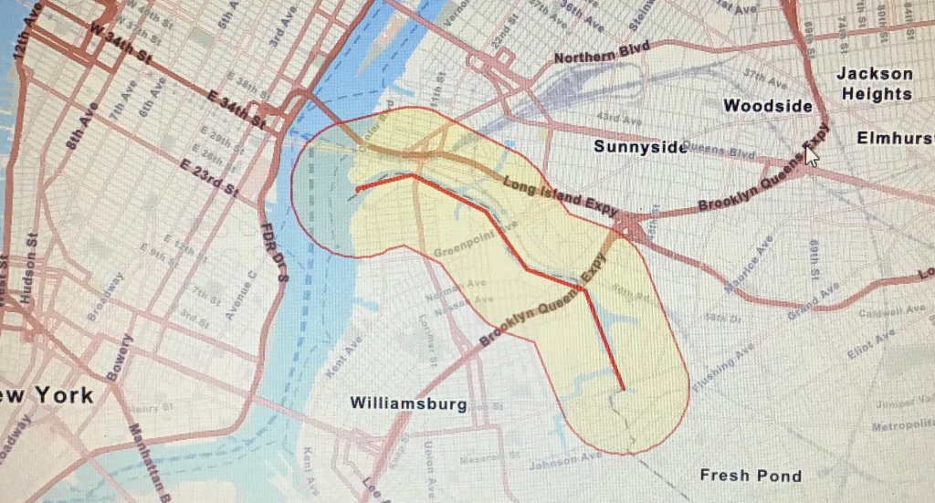
The following data analysis summary is the result of information pulled from the EPA’s environmental justice screening and mapping website (EJSCREEN). The overall goal of this website is to allow people to have access to environmental pollution information for any regional or non-regional areas. The regional area I decided to indicate was Newtown Creek, which runs through mostly Brooklyn and Queens in New York City. With pollution being the forever issue of the creek, it is full of toxic waste, sewage, PCB’s, oil, and much more.
I decided to use a 0.5 buffer along the entire creek when collecting my information. The information and data I collected provided water pollution, air pollution, traffic, and demographics that shows the gentrification happening around the creek. Acknowledging those affected by percentile gives a better visual for communities so they can see they are not the only ones experiencing injustice. Injustice in the sense that pollution, toxin levels, and population are on the rise all while waiting for solutions to these global issues. It is imperative for data to be collected and action to be taken to serve these underrepresented communities.
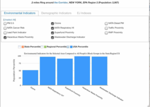

The Environmental Indicators that are important have to deal with the ozone, human respiratory system, wastewater discharge, and the superfund site itself….. According to the data, about 50% of the population are affected by Ozone pollution. The Ozone pollution is essential because it represents the amount of pollutants that affect the ozone. At a ground level this correlates with Newtown Creek’s pollutants because the toxins evaporates up into the ozone affecting the surrounding air quality which will later play a role in the data found in the demographic indicators. Also, more than 90% of the population is affected by NATA Respiratory HI*. This supports the ozone data because it is a representation of how harmful this pollution is to the human respiratory system. Around 90% of the population is also affected by Superfund Proximity and wastewater discharge. Wastewater discharges contain pollutants that prevent access to water. Along with the previous pollutants, contaminated water is harmonious to the human population and creates limitations on cooking, cleaning, and etc.
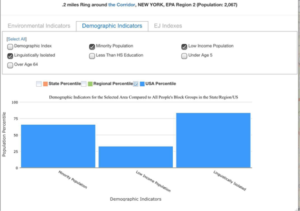

The Demographic indicators that correlate with the environmental factors are the minority, low income, and linguistically isololated populations. These demographics correlate with the environment because it gives possible reasons as to why this type of pollution occurs and still exists today. More than 50% of the people are a part of the minority population, approximately 30% of the people are considered low income, and more than 70% of the population are considered linguistically isolated. This correlates with previous information because it gives some background information as to why this area is not noticed more outside of Brooklyn and Queens. Also, explains how pollution could have gotten the way it is outside of the Exxon oil spill.
Both indicator sectors have concluded that the environment and demographic go hand in hand with one another. Through this observation of data I have discovered that even though the majority of the industrial businesses within this industrial area have been relocated or shut down due to New York’s attempt to deindustrialize these areas, it is still very much populated and polluted by factories. These factories play a role in the pollution of air and water. The foundation of Brooklyn and Queens also play individual roles as well because of the crippling sewage systems and impromptu way of disposing of hazardous waste. Even though the 0.5 buffer placed along the Newtown Creek shows that these areas are populated by a lot of linguistically challenged minorities it explains how information may be slipping between the gaps when informing communities.
Oral Interviews:
Video Story:
Newtown Creek is a high level polluted body of water that runs through Brooklyn and Queens New York. The communities that live along this creek are surrounded by industrial areas and pollution. Urban communities have a lot of expressive artwork throughout these boroughs that promote their thoughts and feelings towards their surrounding environment. This video is a collaboration of images over a period of time (19th century – present day) and is layered with a poem I have written which was inspired by these images and a Brooklyn spoken word artist by the name of Fenna Thomas.